

Israel Is Preparing Land in Rafah to Corral Palestinians into an Area Under Full Military Occupation
Satellite images analyzed by Forensic Architecture show Israel razing land, compacting the ground, and clearing rubble in Rafah in a way that is not visible anywhere else east of the yellow line.


Drop Site is a reader-funded, independent news outlet. Without your support, we can’t operate. Please consider making a 501(c)(3) tax-deductible donation today.
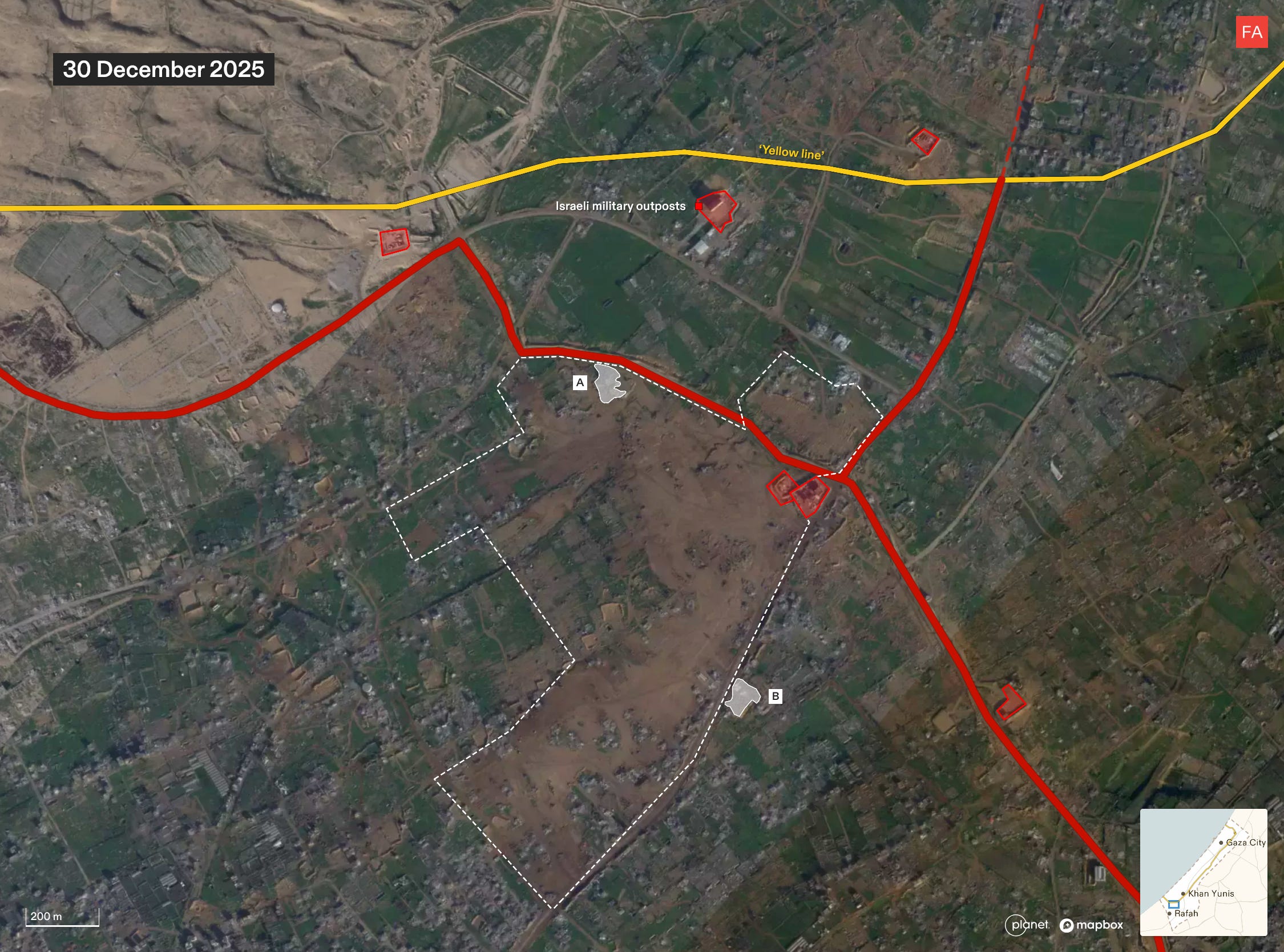
Israel is razing a strategic area of Rafah in southern Gaza, compacting the ground, and clearing rubble in a way that suggests the land is being prepared for the construction of new residential infrastructure, according to new research by Forensic Architecture. The findings, which are based on an analysis of satellite imagery, suggest that Israel is beginning to build infrastructure which may be used to house Palestinians and effectively contain them in an area under full Israeli military control.
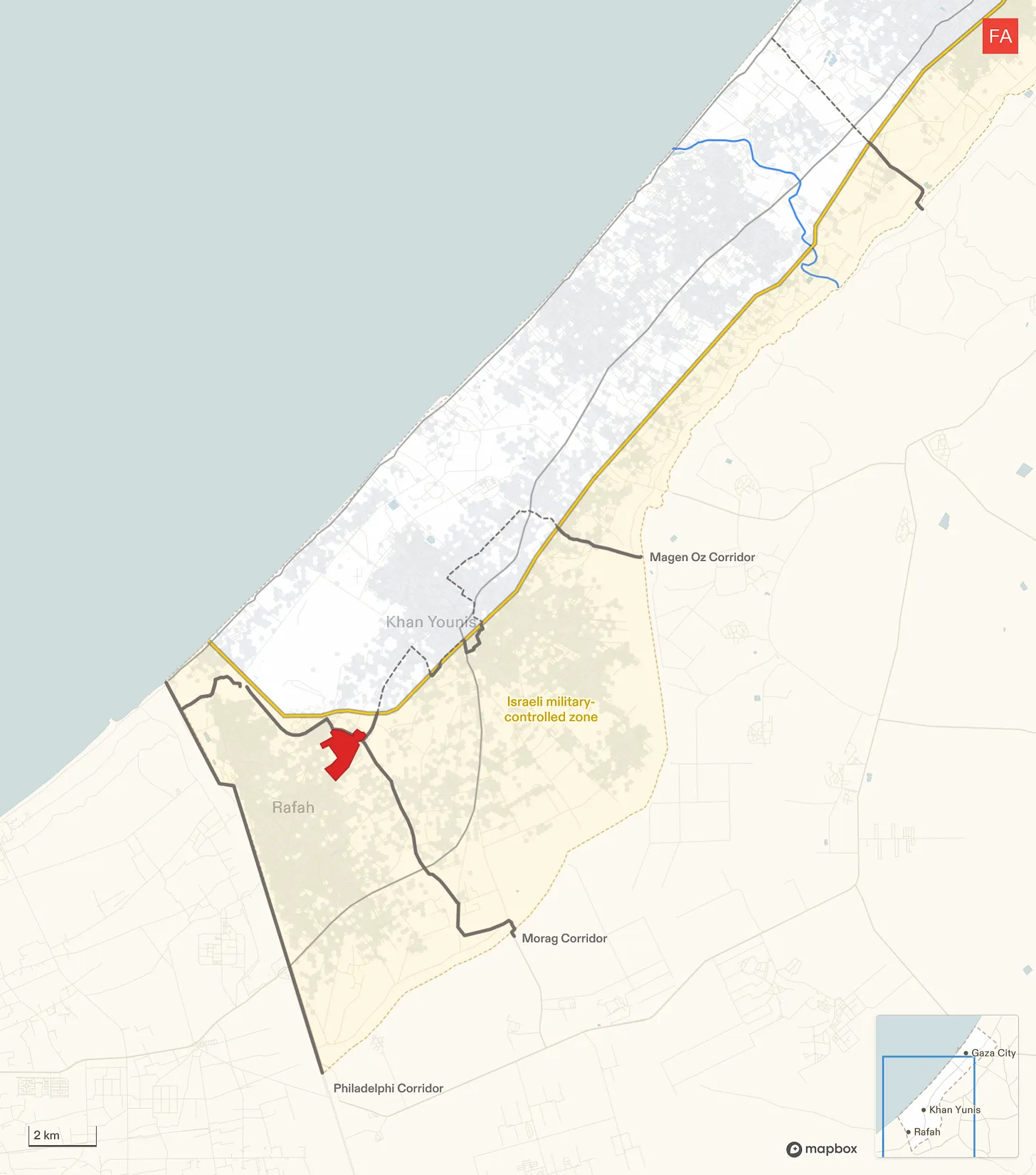
Since the so-called ceasefire went into effect on October 10, Israel has engaged in widespread destruction of buildings and infrastructure across the more than 53% of Gaza that it occupies east of the yellow line. However, this pattern of Israeli activity—razing the land, compacting the ground, and clearing the rubble—is not visible at this scale anywhere else east of the yellow line. The activity is centered in an area around 1 square kilometer in Rafah at the intersection of the two military corridors.
The location lies on the northern edge of what Israeli Defense Minister Israel Katz first announced in July would be a planned “humanitarian city” that would eventually house the entire population of the Gaza Strip. More recently, it emerged in November that the Trump administration was reportedly planning the construction of a number of residential compounds, dubbed “Alternative Safe Communities,” in areas east of the yellow line to provide housing to tens of thousands of Palestinians. The Israeli military was expected to begin clearing the first site for those compounds in Rafah, according to the New York Times. Earlier this month, Israeli military officials told Haaretz that the area is designated for the construction of a residential zone for around 20,000 people.
The Israeli military did not immediately respond to an inquiry from Drop Site News about the site.
The Full Forensic Architecture Analysis
New development site on the ruins of Rafah
Since December, Israel has undertaken groundwork for what seems to be a development site in east Rafah, within the Israeli military-controlled zone. It sits at the intersection of the Morag and Magen Oz corridors, close to the “yellow line.”
Our analysis of satellite imagery suggests that this area is being prepared for the construction of infrastructure, possibly as part of Phase 2 of Trump’s plan to build so-called “Alternative Safe Communities” to house tens of thousands of “non-Hamas affiliated” Palestinians within the Israeli-controlled area.
The area is relatively intact
A close-up of the area shows that in March 2025, at the end of the ceasefire, the area still contained residential buildings and greenhouses relatively untouched by Israel’s military campaign.

Structures are destroyed, and the land is partially cleared
In the months that followed, Israel renewed its ground invasion in Rafah, carrying out largescale destruction and clearing part of the land.
A military outpost was constructed in the northeastern corner of the area, along the new Morag corridor.

The land is cleared and the ground is compacted
After the second ceasefire came into effect, Israel expanded the military outpost. Since December, it has completely cleared the area and compacted the ground.

Rubble from the destruction is cleared
Once cleared and compacted, the Israeli military removed the rubble of buildings it had previously destroyed.
In doing so, Israel has not only erased the existence of Palestinian homes, greenhouses, and agricultural land, but the physical evidence of its destruction, as well as any bodies possibly buried under the rubble.

Amid ongoing destruction and clearing, this pattern of activity is notable
Zooming out on the satellite image from 30 December 2025, you can see that, while destruction and clearing are ongoing across Rafah, this pattern of groundwork — razing the land, compacting the ground, and clearing the rubble — is so far contained to this 1 kilometer squared.

Satellite images show rubble being collected along the perimeter of the area. Source: Planet Labs PBC.
The area is surrounded by military infrastructure
The area of interest is half a kilometer into Israel’s area of control, bound by two military corridors, and near the camp of the Israeli-affiliated “Counter-Terrorism Strike Force,” several military outposts, and former GHF sites. This environment suggests supervision and control, rather than humanitarianism.

“Humanitarian” infrastructure
Rafah has been cited in numerous Israeli plans for “humanitarian” or “transit” infrastructure, and as part of Israel’s efforts to concentrate Palestinians in southern Gaza, near the border with Egypt.
The area of interest is on the northern edge of the planned “humanitarian city” in Rafah — a “secure” zone intended to concentrate Gaza’s population, that Israeli defense minister Israel Katz announced in July 2025.
Rafah is also where the Israeli military was reportedly expected to start clearing the first site for one of the “Alternative Safe Communities.”

To read more of Forensic Architecture’s analysis of Israel’s conduct during the ceasefire visit frames.forensic-architecture.org/gaza/ceasefire.
For additional maps and data on Israeli military conduct in Gaza since October 2023, visit gaza.forensic-architecture.org/database
 | A guest post by
|
A concentration camp within a concentration camp.
This is reminiscent of the United States' creation of the Native American reservation system. Take control of indigenous lands and remove the indigenous people from it through violence, environmental destruction and forced treaties that were subsequently ignored, making the land no longer livable (e.g., kill all the buffalo), combined with concentrating the inhabitants in exceedingly small areas (e.g., Trail of Tears) that were not well-supported, in an effort to marginalize and destroy indigenous culture, while using the previous indigenous-inhabited lands for colonization and resource extraction (cattle, mining, agriculture, railroads, settlers). The entire process was founded on racism, dehumanization, land appropriation and wealth transfer.